Category:Lag Tuleritg
Jump to navigation
Jump to search
| Object location | | View all coordinates using: OpenStreetMap |
|---|
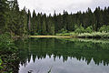
lake at Flims in the canton of Grisons, Switzerland  | |||||
| Upload media | |||||
| Instance of | |||||
|---|---|---|---|---|---|
| Location | Flims, Imboden Region, Grisons, Switzerland | ||||
| Basin country | |||||
 | |||||
Media in category "Lag Tuleritg"
The following 9 files are in this category, out of 9 total.
-
 2011-07-25 10-17-32 Switzerland Graubünden Flims Waldhaus Lag Tuleritg.jpg 4,288 × 2,848; 8.78 MB
-
 2011-07-25 10-17-53 Lag Tuleritg.jpg 2,848 × 4,288; 8.73 MB
-
 2011-07-25 10-18-09 Lag Tuleritg.jpg 4,288 × 2,848; 6.66 MB
-
 2011-07-25 10-18-12 Lag Tuleritg.jpg 4,191 × 2,783; 6.96 MB
-
 2011-07-25 10-18-58 Lag Tuleritg.jpg 4,288 × 2,848; 7.28 MB
-
 2011-07-25 10-20-08 Lag Tuleritg.jpg 4,288 × 2,848; 6.84 MB
-
 Lag Tuleritg 1977.JPG 2,119 × 1,489; 631 KB
-
 Lag Tuleritg eastwards.jpg 3,264 × 2,448; 3.03 MB
-
 Lag Tuleritg.jpg 2,496 × 1,664; 1.9 MB


